Last month, I was inspired by one of Lawren Harris’s paintings to investigate gasometers in Toronto and Paris. A second visit to the Lawren Harris exhibit at the Art Gallery of Ontario evoked another parallel between the two cities: the destruction of an entire neighbourhood in both cities to create a grand public space.
In Toronto, the lost neighbourhood was called The Ward (full name: St. John’s Ward). This collection of ramshackle houses a stone’s throw from the majestic old City Hall was a place in which many immigrants started out in Canada. The housing stock wasn’t much to look at, but there were churches and synagogues, schools and playgrounds, shops and restaurants, and thousands of inhabitants. In the image below, painted in 1911, Harris shows the contrast between the tiny houses of the residents and the huge Eaton Manufacturing Building to the east of the Ward, where many of them worked.

A photograph taken by William James from the top of that building, looking west, offers a different view of the Ward.

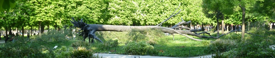
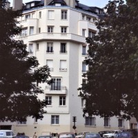
Of course, a neighbourhood of small, poor-quality houses smack in the middle of a growing city could not hope to survive forever, and the Ward was obliterated in the 1950s and 1960s to make way for Toronto’s modernist city hall, designed by Finnish architect Viljo Revell, and a huge civic space in front, known as Nathan Phillips Square, with parking underground. This is a photo I took there a few days ago.

The destruction of the Ward to create City Hall and its public square got me thinking about a vanished neighbourhood in Paris: the one that stood where I.M. Pei’s pyramid now stands, where the lawns and flowerbeds of the Louvre open out towards the Tuileries Gardens. Here is a Google Earth view of what it looks like today.

But this was once the Quartier du Louvre, a bustling neighbourhood of streets and sizable houses, as well as churches, the royal stables, a theatre, and a hospice for the blind. You can see many of these things in the 1730s Turgot map.

Even the Cour Carrée of the Louvre (the big square at the top of the image) has little houses in it. According to David Hanser in The Architecture of France, these particular structure were “temporary buildings, some of which housed workshops for sculptors (and some housed prostitutes).”* But hey, the king was miles away in Versailles; official attention was elsewhere.
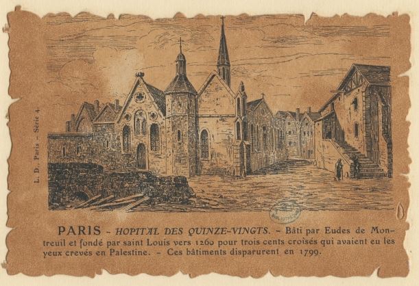
If those houses were temporary, many of the others were centuries old. Turgot’s map shows an important institution: l’Hôpital des Quinze-Vingts (the name means 15 x 20 or 300, the original number of inhabitants) near the Palais-Royal.

It was founded in the 13th century by St-Louis, originally for those blinded in military service, later for impoverished blind residents of the city. As you can see, it even had its own cemetery. An image from Gallica shows a portion of the original buildings.
The hospital moved to its present location on the rue de Charenton in 1779. The old buildings in the Quartier du Louvre were demolished and a street called the Rue de Chartres was created, running at a diagonal to the surrounding streets.
At the other end of the rue St-Thomas-du-Louvre from the Quinze-Vingts, near the river, two tiny spires are visible on the Turgot map, one on each side of the road.

The spire closer to the Place du Louvre was that of the church of St-Nicolas, the other belonged to St-Thomas. (Interestingly, the St. Thomas for whom it was named was not the apostle with the doubts, but Thomas Becket, the bishop murdered in Canterbury Cathedral in 1170 who inspired various books, plays, and movies.)
What little I could find about these vanished medieval churches described them as “collegial.” This meant that they were each a part of a religious community in which university students studied and boarded – or just boarded, as some of these places were little more than student lodging houses. Most such “colleges” disappeared during the 18th century (unlike their counterparts in Oxford and Cambridge).
The tower of St-Thomas fell down in 1739, whereupon the two establishments were merged, St-Thomas was rebuilt, and St-Nicolas was demolished. The merged entity became known as St-Louis-du-Louvre. Part of the ruined apse of the former church of St-Thomas survived into the 19th century, as shown here.

Turgot’s plan also shows several “hôtels particuliers” (Longueville, Créqui, Crussol), which had various names over the years depending on their occupants, and served a variety of functions during the Revolution (this neighbourhood was in the centre of the action). The history of any one of them could fill a separate blog.

The Ecuries du Roi (King’s Stables) occupied several buildings near the Tuileries, and an image from Pugin’s Picturesque Paris shows what they looked like in the 1820s.

A map by from the 1720s by the Abbé Delagrive marks the “Chateau d’eaux” in large letters: this structure directly opposite and facing the Palais Royal was a waterworks in the form of a building with a fountain where the main front door would normally be.


A latecomer to the neighbourhood was the Theatre du Vaudeville, which opened in 1792 on the rue de Chartres, but burned down in the 1830s.

All in all, a bustling neighbourhood where aristocrats, clergy, students, ostlers, performers, and many others lived and worked for generations, a neighbourhood established long before the Tuileries Palace was built in the 16th century. But the whole thing disappeared in the 19th century.
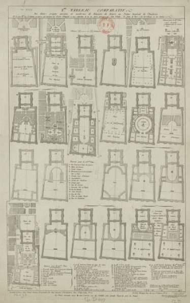
For years, architects had proposed creating a huge courtyard between the Louvre and the Tuileries. There were dozens of plans, and this image from Gallica shows what some of them looked like.
Removing the existing neighbourhood was never considered a particular impediment – what bothered the architects much more was the fact that the original Louvre and the Tuileries did not line up precisely. The Tuileries was at a slight angle. Annoying, that.
The relocation of the court to Versailles put these plans on hold for more than a century. Then came the Revolution. Then came Napoleon.
December 24, 1800. Napoleon is First Consul, and lives in the Tuileries. His wife Josephine asks him to accompany her to a performance of Haydn’s Creation at a nearby theatre. They take separate carriages from the palace; Josephine’s carriage includes her daughter Hortense and Napoleon’s pregnant sister Caroline. Royalists plan to explode a barrel of gunpowder (ever after called a “machine infernale”) as Napoleon’s carriage passes the intersection of the rue St-Nicaise and the rue St-Honoré. But the explosion happens a few seconds after the Consul’s carriage has passed the spot and a few seconds before Josephine’s carriage reaches it; several people are killed, but the Consul, Josephine, and their frightened family members survive. This dramatic, if unrealistic, image tries to capture the mayhem.

Napoleon, fed up with the apparently dangerous neighbourhood that was encroaching on his palace, revived the plans to complete the Louvre-Tuileries complex by clearing the area of its houses and narrow streets, adding a new gallery connecting the Louvre and the Tuileries palace, and opening up a huge interior courtyard. Work began on the wing that now faces the rue de Rivoli. But Napoleon was not in power long enough to see the full plan completed.
The demolition of this neighbourhood happened in slow motion compared with the demolitions in the Ward that preceded the creation of Toronto’s new city hall. But then, the buildings were much more than mere shacks. For example, when I searched for information about the Chateau d’Eau, I found several images of a street battle that took place there during the Revolution of 1848. The buildings around and behind it still look pretty solid.

And a map from 1841 shows a few remaining blocks between the Louvre and the Tuileries.

It was Napoleon III who oversaw the completion of decades-old plans for this area in the 1850s and 1860s, including the final clearance of the Quartier du Louvre. It was only one of many neighbourhoods that vanished during that period.

The complete Louvre-Tuileries complex did not stand as a whole for long. The Tuileries was torched in 1871 during the brief and bloody period of the Commune that followed the fall of the Second Empire. The palace stood as a ruin until 1882, when it was demolished, thereby opening the Louvre’s newly established interior courtyard to the vista of the Tuileries gardens and the Champs-Elysées.
The space has undergone many transformations since then. In the 1950s, it was little more than a landscaped parking lot. Today it is a showplace with a glittering pyramid, carefully tended gardens, and a traffic roundabout for cars and buses; the parking is underground. But once upon a time, people lived and worked here, just as they lived and worked in the Ward now occupied by the square in front of Toronto’s City Hall.
I don’t suppose that either Paris or Toronto is unique in this way. Do you live in a city where a neighbourhood was erased to make way for a public space? Do you know what once stood there?
Text by Philippa Campsie; historic maps and images of Paris from Gallica and Wikipedia. Harris painting image from Vancouver Masters Gallery; James photograph from History to the People.
*David Hanser, Architecture of France (Greenwood Publishing, 2006), p. 120.


Norman can tell you about the area of Ottawa that had been working people’s housing that was demolished some time ago and then left as large grassy fields for many years. When Pope John Paul II visited, a papal mass was held there for many thousands of people. I understand there is something being built–or has been built–there (haven’t been to Ottawa for many years). Maybe Norman would remember the name of the area, as I have forgotten.
You’re right…Lebreton Flats! I think it is still under construction. As many plans for that part of the city as there were for the Louvre.
Thanks,
Philippa
Thanks for such detailed research. I have a CD-ROM of Turgot’s map and I confess I have a hard time unpacking it. This helps a lot! I love all your blogs…don’t ever quit!
I can stare at the Turgot map for hours. Several of the images used on the blog were photographs that I took of a massively enlarged version that we saw on a wall in a booth in the Grand Palais during an exhibit of antiquarian books and prints. It held my interest longer than anything else there.
Bonjour Philippa, Bonjour Norman,
merci pour le post. Connaissez-vous ce document étonnant sur Paris au XVIIIe s.? Amitiés.
https://lejournal.cnrs.fr/articles/ecoutez-le-paris-du-xviiie-siecle
Merci beaucoup. C’est extraordinaire ! Mais où sont les gens ? Ça fait un effet un peu bizarre de les entendre sans les voir !
An interesting bit of history. I don’t know much about what has happened to my neighborhood in Chicago except that the Biograph, my local theater, has been declared a national monument because John Dillinger was trapped and killed by the feds there in the early ’30s.
I enjoyed reading this. In our city there are suburbs now under water, the result of damming the river to form an artificial lake.
Which city is that? Please tell us more.
Philippa and Norman
It’s Canberra. The artificial lake was part of the 1913 design for the new capital by an American architect, Walter Burley Griffin, but the lake wasn’t constructed until 1963. There were previously wooden houses, sports and pastoral grounds on either side of the river.
One of my father’s aunts worked with WBG on the landscaping of Canberra and around the lake. My husband grew up sailing on the lake.
Wonderful history, Philippa. I had never heard of that incident in the life of the young First Consul! In Los Angeles, so many blocks of buildings are regularly razed and then built anew that we find we cannot remember exactly what was at the corner of X and Y even three weeks ago! And many neighborhoods were split asunder to build the freeways. Of course, this makes those characterful buildings that survive all the more precious.
That’s so true. Suddenly there is a space where a building once stood and one cannot remember what was there. I’ve been known to resort to Google Street View to jog my memory!
A wonderful read. Thank you for your marvellous posts.