I have a weakness – no, a fondness – no, a passion for old maps of Paris. On a visit a year or so ago, I bought three old maps from an antiquarian bookseller. During our annual New Year’s tidy-up, I came across those maps again and realized I had never taken the time to study them closely.
They had been published in Histoire physique, civile et morale de Paris depuis les premiers temps historiques jusqu’à nos jours, by Jacques Antoine Dulaure in about 1825. The maps were created by Jacques-Marie Hacq using information provided by Dulaure.
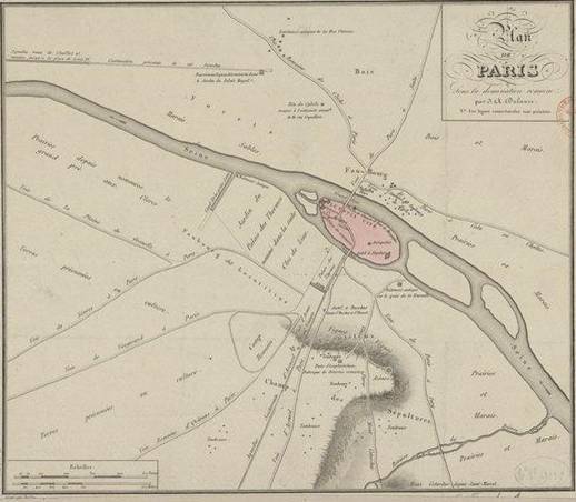
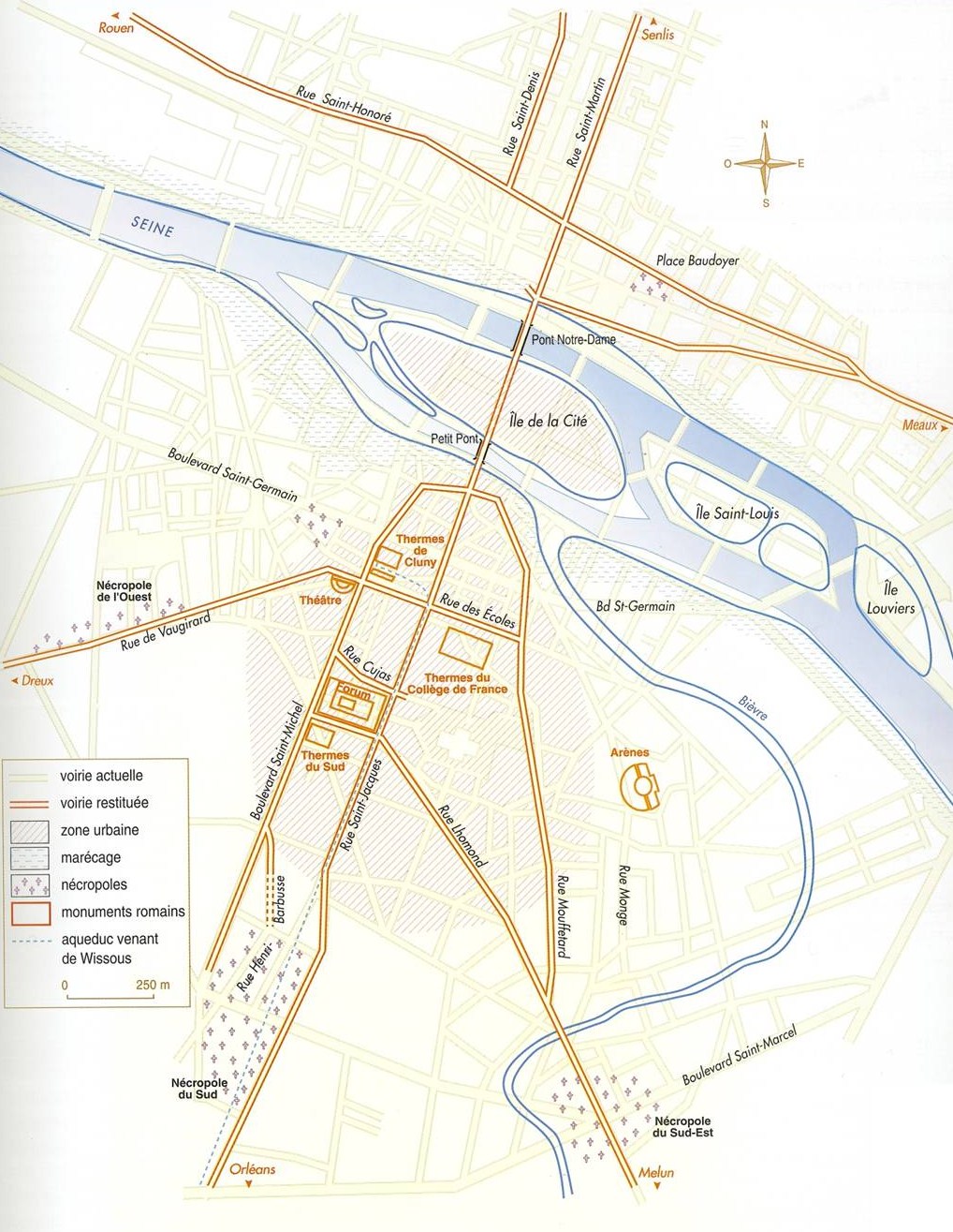
This one, from the first volume in this multi-volume work, is called “Paris under Roman domination” and includes elements of the Roman city that had been discovered by archaeologists up to that point. Much more is known now, but Dulaure did his best with the available information and with some creative theorizing. So what you see here is not a map of Roman-era Paris, it is a map of what an early 19th-century historian knew and conjectured about Roman-era Paris. Which in some ways is even more interesting.
Note the number of islands in the middle of the river – five. Only the Ile de la Cité is identified (as Lutetia Cité); the others are left blank. If the Romans used these islands, they left no traces that had been found as of the 1820s. Other maps show different numbers and configurations of islands, but historians agree that there were once several in the Seine here. Only two remain. (The third-largest and the furthest upstream, once known as the Ile Louviers, is now part of the Right Bank.)
The areas on both left and right banks are labelled as “Faubourgs” (suburbs) and many tombs are marked (tombs survive when traces of the living have been erased). To the east are marshes (marais) and plains (prairies), to the north west are forests, marshes and sandy areas (sables), and only the southwest part of the area is (Dulaure presumes) devoted to agriculture.
The map also shows roads leading out of the city in all directions, two dead-straight aqueducts (an overground one from Chaillot and an underground one from Arcueil), and the Bièvre River (with some small islands of its own), before it was channelled and redirected to empty into the Seine farther downstream.

Lutetia Cité, hand–painted a faint pink, contains a fortress, a prison (Prison de Glaucin et Tour de Marquefas* – Hacq renders this as Tour de Margnefas), an altar to Jupiter, a marketplace (Place du Commerce), a “cippe antique” (funerary monument), and something vaguely marked “Antiquités” roughly where Notre Dame Cathedral is today.

Dulaure describes each of these elements and explains why he has placed them where he has, using evidence from older texts, archaeological discoveries, etymology, and oral traditions. For example, he says he knows that there was a prison on the island, because it is mentioned in the writings of Gregory of Tours in the 6th century. He placed it where the flower market is now because there were earlier churches here with names that indicated their proximity to a prison. As theories go, it’s not bad.
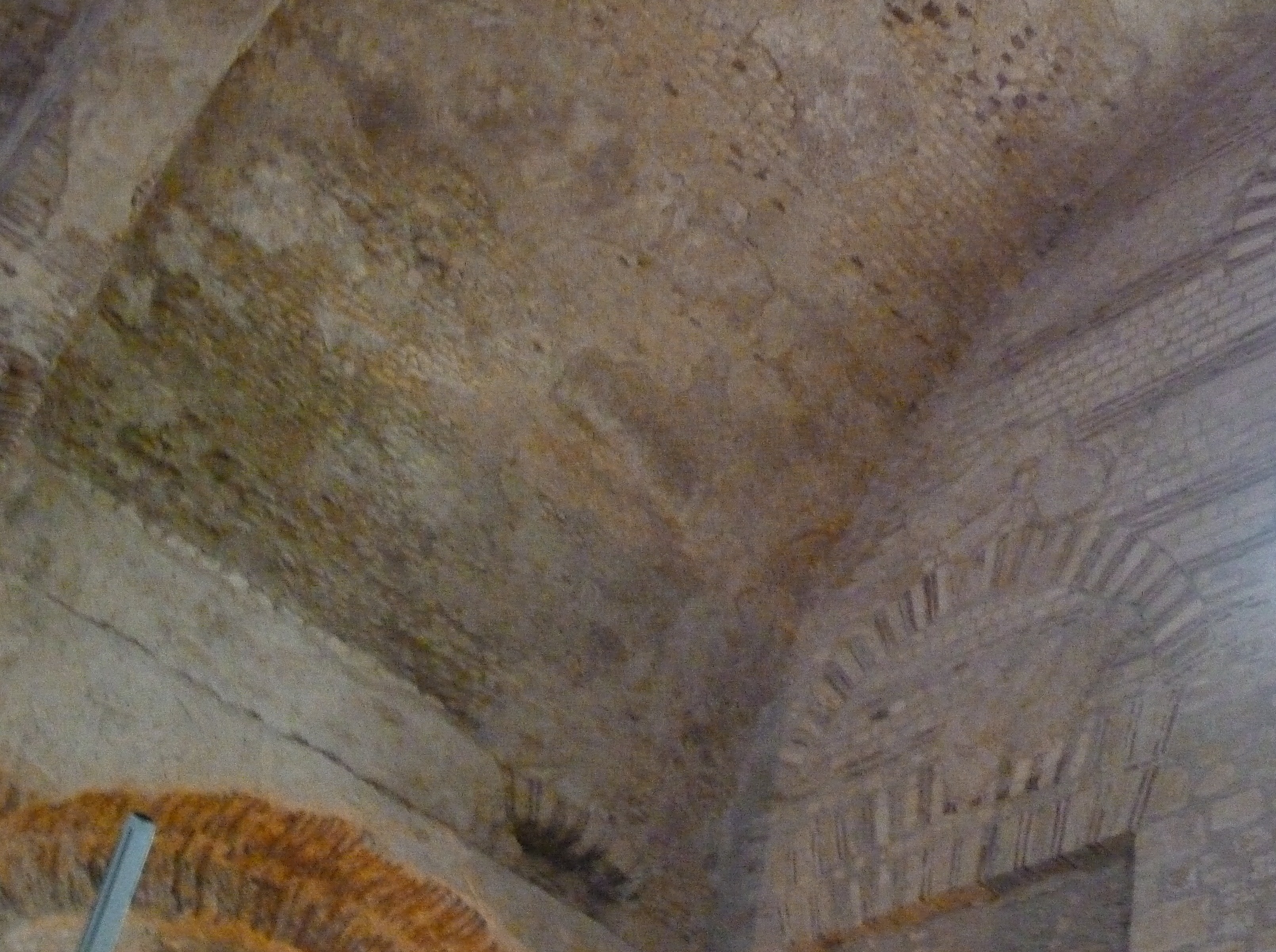
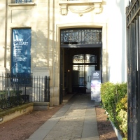
On the Left Bank is a huge “Palais des Thermes,” with spacious gardens, bordered to the west by a short canal. The size and orientation of the palace are approximate, but the Roman baths now incorporated into the Cluny Museum would have been part of this complex. (This not-very-good photo shows some of the Roman brickwork in the frigidarium at Cluny.)
 Dulaure adds the garden to the west (he notes that other historians do not mention a garden) with the explanation that Roman baths and major buildings were usually associated with gardens and that 6th-century accounts refer to a garden here. He notes that it was later called “Clos de Lias.” Clos means vineyard, and he traces the origin of Lias as a version of the French article Le plus a modified version of “Arx,” meaning palace or citadel.
The canal marked as “La Petite Seine” to the west of the gardens of the Palais des Thermes lies roughly where the rue Bonaparte is now. There was a stream emptying into the Seine at about this point (now buried), but it is not clear when it was turned into a canal. Some historians had suggested that it was built much later, connected to the moat of the fortified Abbaye St-Germain (the Abbey and its fortifications came long after the Romans had departed). Dulaure disagrees. He insists that the canal was useless as a defence against invaders, and notes the discovery in 1806 of some large foundation stones and gold medals dating from the 3rd century in this spot. He concludes it was an ancient construction, possibly built to enhance the Roman gardens.
On the Right Bank is the Place Tudella – spelled Tndella on the map (Hacq was clearly a bit sloppy with spelling). Dulaure says that Tudella was a common name in ancient France that designates a fortification. Another French antiquarian, however, writing in 1753, had suggested that the name comes from the Latin word for mallet (tudes), and that this was a place on which a game was played with mallets (the jeu de mail, which was rather like croquet). Not sure I can visualize the ancient Romans playing croquet, so I’d give Dulaure the benefit of the doubt on that one.
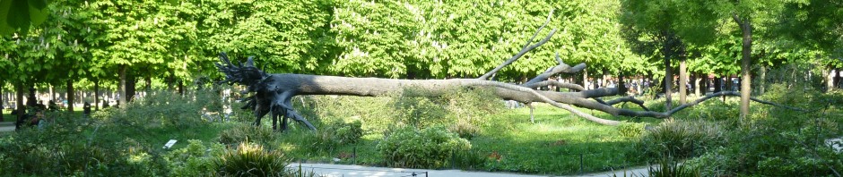
The Arena now known as the Arènes de Lutèce is shown on the map, but its location would have been mere conjecture in the 1820s. Apparently it had long been known that an arena had existed on the Left Bank, but its remains were not discovered until excavations for a tramway in the 1860s. On this map it appears on the side of a hill labelled “Mont Locutitius.” This is where Mont St-Genevieve is now. Today part of the arena has been excavated and is open to the skies.
Here and there Dulaure has noted a few archaeological discoveries, such as the “Tête de Cybèle trouvée à l’extremité orientale de la Rue Coquillière” (Head of Cybèle found at the eastern end of rue Coquillière). Cybèle was a mother goddess and a bronze head depicting her (she wears a castle on her head like a crown) was found in 1657 near the church of St-Eustache. The head, the authenticity and provenance of which have been questioned, is now in the collection of the Musée des monnaies, médailles et antiques of the Bibliothèque Nationale de France.
 Another site is marked as “Autel à Bacchus depuis S. Benoit et S. Bacchus.” The altar would have been dedicated to the Roman god of wine and festivity, but St Bacchus (no relation) was a 4th-century Christian martyr from Syria. A church built here called St-Benoit-le-Bétourné celebrated St Bacchus and his fellow martyr, St-Serge. (“Bétourné” refers to the fact that the church was the wrong way around – normally churches are oriented with the altar to the east, but this one had its altar to the west.)
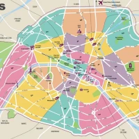
About 150 years after Dulaure wrote his book, a group of historians recreated what they knew about the city in Roman times, in a map created for an exhibit in the Carnavalet Museum in 1984 and republished in Atlas de Paris. There are differences from Dulaure’s map, but on the whole Dulaure holds up pretty well.
In future blogs, we’ll look at the maps of 13th-century and 16th-century Paris from Dulaure’s book.
Text by Philippa Campsie; original photograph of the Arènes de Lutèce by Norman Ball; original photograph of the Cluny Museum by Philippa Campsie. Final map by Jean-Pierre Adam and Philippe Velay, from Atlas de Paris, Parigramme, 1999. The image of the map itself is the Gallica version, because mine is too large for my scanner. Other images are from the Google Books version of Dulaure.
For more information about Roman-era Paris, we highly recommend the website Paris, A Roman City.
* The Tour de Marquefas was later called the Tour-Roland and Victor Hugo uses that name in Notre Dame de Paris, 1831, published a few years after Dulaure’s history. Hugo’s book also refers to the Prison de Glaucin. It is possible that Hugo had a copy of Dulaure and referred to it in recreating medieval Paris.


Fascinating choice of topic!
Love old maps. On one of my trips to Paris, I bought an inexpensive print of a 1575 version and it framed beautifully. I can study it endlessly.
I know exactly how you feel. I can stare at maps endlessly, and I always learn something new. Philippa
Love the blog – I’m working on a collection of maps myself. Any suggestions on where specifically to find good copies ? I don’t need originals… Also, I’m on the hunt for a reduced-size Turgot (I don’t have the room for the original size !) – any ideas there?
It depends on what quality you need. You can print maps out from the Gallica website (their map holdings make me feel like a kid in a candy store), which are fine for research purposes. However if you want to frame them, you may have to search farther afield. Check out Period Paper, which sells originals and copies. As for Turgot…hm, I’ll have to get back to you on that.
Very much enjoyed this post. I had no idea that there were originally five islands. Look forward to your future map posts.
There may have been more than five. The map at the end of the blog shows that what is now the Ile St-Louis was originally two islands — other maps give these the names Ile Notre-Dame and Ile aux Vaches.
I do enjoy old maps. Thank you. I am a collector of old postcards, though primarily artist-signed cards of children but many othe subjects too. I have forwarded your email to a dealer in Paris who deals in paper as well as postcards.
Regards, susan Scott
Pingback: Walls within walls | Parisian Fields
Has anybody visited the underground excavated museum at the end of the Plaza opposite the Notre Dame cathedral? Fascinating original wall fortifications and surviving evidence of under floor thermal heating?
It has long been on my to-do list. Thank you for the reminder!
Hi Norman and Philippa. May I use an image of one of the maps in a blog post I will be doing next week? Here is the link to my blog: http://saxonhenry.com – I will link back to you, of course. You have a terrific site!
Yes, of course. What is the subject of your blog?